Earth Survey Maps (ESMaps) Reference
See also Earth Survey Maps - Mobile (ESMaps-m).
ESMaps is an implementation of the Google Maps JavaScript API version 3. It includes an address geocoder and selected components from HCBM, NGSCS, PLSGE, and QUADS.
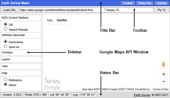
TITLE BAR
TOOLBAR
Type or paste an address, place name, or comma-separated latitude and longitude pair in the input field and click Fly To to search for the location corresponding to the given address or place name, or the address corresponding to the given location.
SIDEBAR
NGS Control Stations
Click Search Results to refresh the network link.
See NGSCS to learn more about NGS Control Stations.
Address Geocoder
Type or paste an address, place name, or comma-separated latitude and longitude pair in the input field and click Fly To to search for the location corresponding to the given address or place name, or the address corresponding to the given location.
Ctrl-Click on the map to search for an address corresponding to the given location.
Shift-Click on a geocoder placemark to remove it.
Alt-Click on a geocoder placemark to edit its name and description.
Drag a geocoder placemark to change its location.
Click Save As to save Address Geocoder placemarks as a KML 2.2 document.
Overlays
Click BLM Townships or Quarter Sections to refresh the respective network link. See PLSGE to learn more about these overlays.
Click National Hydrography, USGS Quad Index, or USGS Topo Maps to refresh the respective network link. See QUADS to learn more about these overlays.
Click Automatic Refresh to toggle the refresh mode.
Use the Transparency slider to control the opacity of overlays.
Layers
Hillsborough County and City of Tampa Benchmarks are components of HCBM.
View
Click an Aspect Ratio selection to conform the current page size to various media in landscape orientation, including standard or widescreen video. Page content cannot be less than 670 px × 380 px.
| Selection Aspect Ratio Minimum Page Size |
Supported Media |
|
| Name |
Size |
|
| letter (11 × 8.5) 1.294117647 776 px × 600 px |
Letter ANSI A |
11 in
× 8.5 in |
| legal (14 × 8.5) 1.647058824 906 px × 550 px |
Legal |
14 in × 8.5 in |
| ledger (17 × 11) 1.545454545 927 px × 600 px |
Ledger Tabloid ANSI B S11R |
17 in × 11 in |
| Statement |
8.5 in × 5.5 in |
|
| wallet (3.25 × 2.5) 1.300000000 715 px × 550 px |
Wallet1 |
3.25 in × 2.5 in |
| 3R (5 × 3.5) 1.428571429 714 px × 500 px |
3R |
5 in × 3.5 in |
| 4R (6 × 4) 1.500000000 750 px × 500 px |
4R |
6 in × 4 in |
| S8R |
12 in × 8 in |
|
| S10R |
15 in × 10 in |
|
| S12R ARCH B |
18 in × 12 in |
|
| 5R (7 × 5) 1.400000000 770 px × 550 px |
5R |
7 in × 5 in |
| 2R Wallet |
3.5 in × 2.5 in |
|
| 8R (10 × 8) 1.250000000 750 px × 600 px |
8R |
10 in × 8 in |
| 12R |
15 in × 12 in |
|
| DIN / ISO / JIS 1.414213562 849 px × 600 px |
A4 |
297 mm × 210 mm |
| A3 |
420 mm × 297 mm |
|
| ISO B5 |
250 mm × 176 mm |
|
| ISO B4 |
353 mm × 250 mm |
|
| JIS B5 |
257 mm × 182 mm |
|
| JIS B4 |
364 mm × 257 mm |
|
| 4:3 video 1.333333333 800 px × 600 px |
Standard |
320 px × 240 px |
| 640 px × 480 px |
||
| 800 px × 600 px |
||
| 4D |
6 in × 4.5 in |
|
| 6R |
8 in × 6 in |
|
| ARCH A |
12 in × 9 in |
|
| 16:9 video 1.777777778 960 px × 540 px |
Widescreen |
640 px × 360 px |
| 800 px × 450 px |
||
| 960 px × 540 px |
||
| 1Sometimes called US Wallet, this
is the Wallet size in Windows Photo Viewer. |
||
Use the free TechSmith Capture desktop application to save an image of the ESMaps page for subsequent printing.
Help
Click About to display copyright, date, and version information.
STATUS BAR
All images and data are retrieved from remote servers. Data errors, accuracy, and availability are beyond the control of this application.