XYZ for Google Earth (XYZGE)
This page describes a free application that runs in
the Google Earth desktop client. Please install
Google Earth,
download
XYZGE,
and return to this page to learn more.
XYZGE is a graphical front end for the NGS online tool, XYZ, that eliminates the need to input geodetic coordinates and displays the converted coordinates in a placemark balloon.
To convert geodetic to Cartesian coordinates:
- Position the point of interest (POI) in the center of the view. One way to do this is to double-click an unmarked location. To precisely position the POI in the center of the view, add a placemark at the desired location; then edit the properties of that placemark and reset the view (explain). For best results, disable automatic tilting (Tools, Options, Navigation, Do not automatically tilt while zooming) and minimize elevation exaggeration (Tools, Options, 3D View, Elevation Exaggeration, 0.01).
- Check the box beside the Geodetic to Cartesian network link. A form will be presented with read-only coordinates corresponding to the view center and an input field for ellipsoid height. Converted coordinates are displayed when the Convert button is pressed.
- On subsequent uses, reposition the POI and ensure that the network link is checked and selected. Then choose Refresh from the Edit menu, or right-click and select Refresh in the context menu (explain).
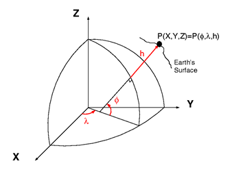
Image NGS
To convert Cartesian to geodetic coordinates:
- Click on the Cartesian to Geodetic folder name to open a form with input fields for Cartesian coordinates.
- Converted coordinates are displayed when the Convert button is pressed.
Note: To save XYZGE results from one Google Earth session to another, right-click on Saved Placemarks and select Save to My Places or Save Place As.
All data are retrieved from remote servers. Data errors, accuracy, and availability are beyond the control of this application.