Range Rings for Google Earth (RINGS)
RINGS is an online tool that draws concentric circles, an annulus, or a sector of an annulus in Google Earth. Ring radii may be specified from 1 to 1,000,000 US survey feet or meters, and from 0.025 to 10,000 miles (1 mi = 5280 US survey ft), nautical miles (1 nmi = 1852 m), or kilometers. Line and area colors are selected from a 24-color palette, line width may be specified from 0.1 to 10, and area opacity may be specified from 0 to 100%.
- Position the point of interest (POI) in the center of the view. One way to do this is to double-click an unmarked location. To precisely position the POI in the center of the view, add a placemark at the desired location; then edit the properties of that placemark and reset the view (explain). For best results, disable automatic tilting (Tools, Options, Navigation, Do not automatically tilt while zooming) and minimize elevation exaggeration (Tools, Options, 3D View, Elevation Exaggeration, 0.01).
- Check the box beside the Setup network link. A form will be presented with read-only coordinates corresponding to the view center and input fields for ring parameters. Range rings are drawn when the Draw button is pressed.
- On subsequent uses, reposition the POI and ensure that the Setup network link is checked and selected. Then choose Refresh from the Edit menu, or right-click and select Refresh in the context menu (explain).
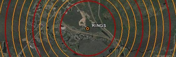
Ring radii are integral multiples of the minimum radius interval, 1 for feet or meters and 0.025 for miles or kilometers. A maximum of 200 rings may be drawn per query. To suppress index rings, enter 0 for the Index Line Width.
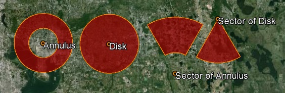
An annulus or sector of an annulus with arbitrary radii may be drawn instead of rings by selecting Annulus or Sector on the input form. To draw a disk or sector of a disk, enter 0 for the Starting Radius. To draw only the boundary of sectors and annuli, enter 0 for Opacity. Sectors and annuli that cross the antimeridian should be drawn with zero opacity to avoid a known Google Earth issue.
Range rings are rendered as regular polygons with 72 vertices on the WGS84 ellipsoid using Vincenty's nested equations. The calculated vertices typically exhibit submillimeter agreement with the NGS online Inverse/Forward computation utilities.
Note: To save range rings from one Google Earth session to another, right-click on Saved Regions and select Save to My Places or Save Place As.